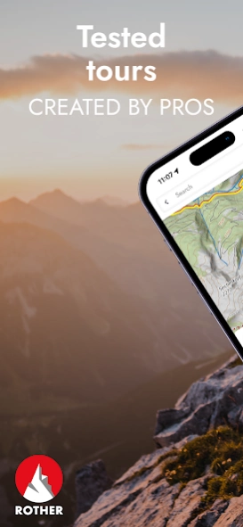
About Rother: Hiking & Bike
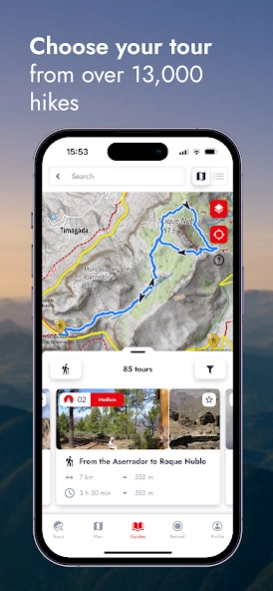
Easy route planning and recording with premium maps and over 13,000 tested tours by professional hiking authors. All Rother tours are now fully available in English. Here comes your reliable companion for the next hike!...
Easy route planning and recording with premium maps and over 13,000 tested tours by professional hiking authors. All Rother tours are now fully available in English.
Here comes your reliable companion for the next hike!
With us there is no mess of useless tours, but only tour suggestions from professional authors - tested and regularly updated. With our maps from qualified cartographers, orientation is easy. For beautiful and safe outdoor experiences.
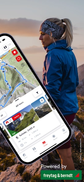
The Rother App is developed and published by Rother Bergverlag, known for reliable hiking guides, and the renowned cartography publisher freytag & berndt.
FREE OFFLINE MAPS
You can download our hiking and biking maps for free and use them offline. You can also plan your own routes and record your adventures.
GET ALL TOURS AND MAPS
You have the choice: Unlock individual guides or get them all in the low-priced Gold subscription. This gives you access to all tours from Rother, all premium maps from freytag & berndt, Swisstopo and the satellite map. You can save tours and locations in your own lists, so you can keep track of everything.
EASY TOUR SELECTION
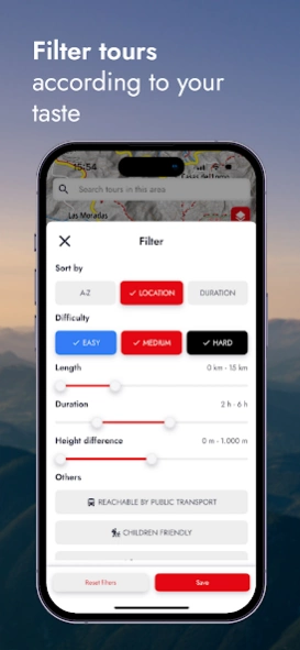
Do you want a leisurely tour today or are you looking for a challenge? Are you looking for a child-friendly hike? No problem: easily filter tours according to your preferences, such as length and difficulty.
HIKING MAPS
Topographic maps in many zoom levels and satellite map. With our premium maps you get the finest cartography from freytag & berndt and others like Swisstopo, BKG, SHOCart, CNIG or Kartverket.
GPS NAVIGATION
While hiking you can always see your location and the track of the tour.
OFFLINE USE
Simply download the map for the desired area and go hiking without an internet connection.
ROUTE DESCRIPTIONS
Reliable tour descriptions and all information about requirements, refreshments, etc.
In a slideshow with photos of the tour you can see what to expect.
PLAN YOUR OWN ROUTE
Route planning with Rother is very easy and understandable: enter your start and destination and we will show you the way - on foot or by bike.
ROTHER GUIDES
You can also get our popular Rother hiking guides. Each guide contains around 50 tested tours by proven area experts.
There are more than 200 guides available for the most beautiful hiking regions worldwide - also for the Way of St. James and long-distance hiking trails as well as for winter (ski tours, snowshoe tours).
If you already have a book from us, you can import the GPS data into the app for free, but not unlock the corresponding guide for free.
ABOUT ROTHER BERGVERLAG
Rother Bergverlag is Europe's most important publisher of hiking guides. The authors are proven area experts who stand for a considered tour selection and the highest quality. All tours are professionally checked in the editorial office.
ABOUT FREYTAG & BERNDT
freytag & berndt is Austria's market leader in the field of cartography. Headquartered in Vienna, the company looks back on 250 years of experience. The extensive product range now includes around 1,500 maps and atlases with a focus on hiking and cycling maps for Austria and Germany, international road and leisure maps, and city maps from Austria and abroad. A team of 50 cartographers ensures that all maps are up-to-date and of high quality.
Previous Versions
Here you can find the changelog of Rother: Hiking & Bike since it was posted on our website on 2023-07-03 23:27:10.
The latest version is 564 and it was updated on 2024-04-22 21:07:45. See below the changes in each version.
Rother: Hiking & Bike version 564
Updated At: 2023-11-27
Changes: - Location dot slightly larger (more visible)
- App available in Hungarian
- Small improvements
Have fun hiking!
Rother: Hiking & Bike version 563
Updated At: 2023-11-27
Changes: - The best tours are marked as TOP
- tour numbers like in the book
- Time calculation for planned/imported tours improved
NEW in Gold subscription:
Warnings if you made a wrong turn!
If you have left the tour, you will get a hint with sound.
And other improvements.
Have fun hiking!
Rother: Hiking & Bike version 562
Updated At: 2023-09-10
Changes: Corrections in
- GPX export
- Planning tours (km calculation)
- App launch on weak internet connection
Have fun hiking!
Rother: Hiking & Bike version 561
Updated At: 2023-06-29
Changes: What is new?
- small corrections
- notifications about new features and offers
By the way, you can find instructions here:
www.rother.de/helpcenter
Disclaimer
Official Google Play Link
We do not host Rother: Hiking & Bike on our servers. We did not scan it for viruses, adware, spyware or other type of malware. This app is hosted by Google and passed their terms and conditions to be listed there. We recommend caution when installing it.
The Google Play link for Rother: Hiking & Bike is provided to you by apps112.com without any warranties, representations or guarantees of any kind, so access it at your own risk.
If you have questions regarding this particular app contact the publisher directly. For questions about the functionalities of apps112.com contact us.